
By: Gordon Barnes, Julian Higgins, and Garrett Moore, January 2016
COMBAT SKYSPOT, REVISITED
In the January 2016 edition of The Photomapper newsletter, we presented an article describing the Photomapping support to Operation COMBAT SKYSPOT in SEA. At the end of that article we appealed to anyone who was involved or knew of someone who was to contact one of the authors so that they could be recognized.
We have had limited success so far in identifying such people. Some of the people involved were identified by name in the original article so will not be noted again here. Among the new names identified are:
Jim Wheeler and Ken Sandine
Jim was a pilot and Aircraft Commander, and Ken was a pilot of, crews which flew the HIRAN Trilateration missions over Laos to position Lima Site-85. These missions were flown out of Tuy Hoa AB in Viet Nam as a mission of AST-3.
Other Photomappers involved with SKYSPOT in SEA were several members of our Geodetic Survey Squadron (GSS) or 1373rd M&C Squadron who at the time were assigned to SAC's 1st Combat Evaluation Group (1CEVG). They are:
John Guerin
Antone Marks
Dick Massetti
Connie Musha
Kip Nissen
These men were ground surveyors who positioned SKYSPOT sites in Laos, Vietnam, and/or Thailand. Guerin and Marks were among six 1CEVG surveyors who were ambushed and killed while enroute to a site near Dong Ha, Vietnam. Massetti, Musha and Nissen were directly involved in an earlier effort to position Lima Site-85 in Laos, before ACGS involvement. Their recon by helicopter resulted in a crash in which no one was injured.
In chasing-down names of other Photomappers who were involved with efforts in neutral Laos, we found some who supported another previously classified mission with the unclassified nickname Operation COMMANDO HUNT. Their missions were also flown by AST-3. They positioned 11 points of interest in Laos using the SCP technique and flew 1686 linear miles of simultaneous HCP/TPR/LORAN photo. Significantly, their missions required flying straight and regular flight lines at a constant altitude well within range of enemy anti-aircraft artillery and SAMS. Members of the aircrews which participated are:
Dennis Davis
Phil Poukish
Bruce Sophie
Davis and Poukish were Navigators and Sophie was a Pilot and Aircraft Commander.
Obviously there were many more Photomappers involved in these missions who deserve to be identified and acknowledged. We would like to continue doing this. So, if you know of any, please contact one of the following:
Gordon Barnes at glbjlb@charter.net or phone 636-227-4327
Julian Higgins at jhjh37@cox.net or 850-651-7004
Garrett Moore at garrettmoore@verizon.net or 703-266-3293.
We particularly would like to identify the three Ground Station Guys who ran the Lima Site-85 Station during its positioning. Thus far we have no leads to their identities.
We would also like to encourage any of those mentioned above who are still with us to write a little something about their involvements, particularly anything that made these missions unique. We would love to publish these stories in this Newsletter and/or on our website. If interested please contact one of the people mentioned in the previous paragraph and they will provide help and support.
PHOTOMAPPING SUPPORT OF COMBAT SKYSPOT IN SOUTHEAST ASIA
PHOTOMAPPING BACKGROUND:
Photomappers first entered the Vietnam War as Aerial Survey Team 1 (AST-1) of the 1370th Photomapping Wing. The date was 25 April 1966. They stayed there in TDY status until 9 June 1966. This effort was in support of Headquarters Air Force Project RAZOR CLAM (AF 66-81). It involved both Aerial Electronic Surveying using HIRAN in their RC-130s and the collection of HIRAN Controlled Photography. Thirteen points were positioned in Vietnam and off its coast and 1350 linear miles of photo were collected. The Photomappers didn't go back to Southeast Asia until July of 1967. In the approximately one year interval between deployments, two significant events took place. First, the 1370th Photomapping Wing was inactivated at Turner AFB, GA and the Photomapping resources were reactivated as the Aerospace Cartographic and Geodetic Service (ACGS) at Forbes AFB, KS. And, in Southeast Asia it became apparent that there were significant problems with Air Force bombing accuracy. LORAN (LOng RAnge Navigation) had been selected by the Air Force as the navigation aid of choice to provide a day/night, all-weather bombing capability, and it was not doing it well. Misses were often measured in miles and not meters and the causes were not known. As a part of the troubleshooting, a team of Air Force cartographers and geodesists was sent to Southeast Asia to try to isolate the causes and recommend corrective actions. Among the Photomappers on the team was Captain Frank Hotter, and it was his observations and recommendations that proved most useful. Most importantly he noted that the war fighters were using targeting materials based on different geodetic datums. The LORAN ground stations were located in Thailand and their coordinates were on the Indian datum. It was on this datum that the LORAN charts, maps and photos being used by Tactical Fighter-Bombers were published. However, the targeteers and others selecting targets in Vietnam were using maps, charts and photography positioned on a datum defined by the French many years prior. The salient fact being that the datum shifts between the Indian and French datums were not known. And, to further complicate the problem, targets in Laos were becoming more and more frequent and important, and little was known about how their survey datum related to either the Indian or French. Officially the Laotian datum was given as the Indian—the same as Thailand, but the adequacy of the survey ties between Thailand and Laos was not known. Also during this year between deployments, something was realized that should have been apparent from the beginning. LORAN signals are highly variable, depending on the time of day, the altitude of the user and even the equipment being used. Ideally, LORAN ground waves would be used everywhere to determine bomb release coordinates. LORAN overlays on maps and charts are printed assuming the use of ground waves. However, this is operationally impossible in day/night, all-weather conditions. The Earth's various atmospheric layers lower at night and the LORAN signals bounce off them, often resulting in what are called sky waves arriving at the receivers, which degrades the accuracy of the positioning. And this, in turn, leads to bombing misses. So, in July of 1967 the Photomappers were ordered back into Southeast Asia, this time as AST-3 of the ACGS. Their job was two-fold. First and most important, they were to support the fighting forces in any way they could through the use of aerial and ground surveying and through the collection of various kinds of aerial, cartographic photography. Second, they were to collect, on a target-of-opportunity basis, any additional surveying data that would better tie the various mapping datums of Vietnam, Thailand, Laos, and Cambodia together into a common datum. In fact, such a datum had already been established by the Department of Defense in 1960 and was known as the World Geodetic System of 1960 (WGS-60). It had been updated in 1966 and published in 1967 as WGS-66. The problem was that these datums had been developed primarily to support our nuclear, strategic forces and thus insufficient resources had been allocated to publish the necessary maps, charts and other targeting materials needed to support a tactical war in Southeast Asia. Not surprisingly, given the above situation, the first major project flown during this second deployment was COMBAT LOOK (AF 67-46). This was LORAN calibration and cartographic photography of the Demilitarized Zone (DMZ) between North and South Vietnam and of a then classified area of the neutral country of Laos. Also not surprising is that the second major effort was nicknamed COMBAT SKYSPOT (AF 68-11). The Photomapper involvement at the time was classified TOP SECRET and it is the subject of this article. It was of relatively short duration, but was the highest priority of any project assigned to the Photomappers during the Vietnam War. It involved both Aerial and Ground Surveying in both Thailand and Laos, in areas of active fighting. Because one of the two sites being discussed was located in neutral Laos, and it was eventually overrun by enemy North Vietnamese forces; and because the resultant battle ended up with the greatest loss of USAF lives during a single ground battle (with one of the casualties subsequently being awarded the Congressional Medal of Honor), the COMBAT SKYSPOT project has received an abundance of attention. At least two books and dozens of articles and blogs have been written about it. However, to our knowledge NONE of them has mentioned the Photomapper involvement. This article is an attempt to rectify this situation. COMBAT SKYSPOT BACKGROUND:
To understand SkySpot you first have to understand the Strategic Air Command. It was formed as a Specified Command of the USAF with the single role of providing Nuclear Deterrence through maintaining two legs of the nuclear Triad in a strong and ready posture. Their aircrews were taught to shun ground based navigation aids as they were surmised to not be available in times of nuclear war. But in order to maintain the desired posture they realized they would need to have constant measures of how they were doing. They formed the dreaded (by their air crews) Combat Evaluation Group or CEG. They were dreaded because they would just show up at your aircraft one day and give you an unannounced check ride. And it seemed to many that they were more interested in complete standardization than they were in mission results. In August 1961 their designation was changed to the 1ST Combat Evaluation Group or 1CEVG. The 1CEVG felt that in order to fulfill their role adequately they would need to be able to measure the accuracy of every bomb drop and every navigation leg of their aircrews training missions. To allow this they developed the MSQ-77 radar and placed them at several locations throughout the United States at sites called RBS or Radar Bomb Scoring sites. Jump now to the Vietnam War. The B-52s of SAC entered the war in 1965 in a much more tactical role. Their nuclear weapons were replaced by conventional bombs and their targets were much more tactical in nature. In fact, at times they were called on to provide close air support to our ground troops. Like the tactical fighter-bombers, their bombing accuracy left a lot to be desired as many of their targets were located under jungle canopy and/or in isolated mountainous regions giving their on-board radar navigators little or no target signatures and no good offset aiming points. Thus they had to resort to carpet bombing to help assure target destruction. This proved to be somewhat ineffective and certainly inefficient and costly. As much as they abhorred ground-based aid, they admitted they needed help, but they wanted to provide it themselves. Knowing the problems with using LORAN, they wanted to bring their MSQ-77 radars into the Theater and use them to direct their B-52s and the fighter-bombers to their bomb release points. This was approved and the concept was called Ground Directed Bombing or GDB. The first GDB sites arrived in-country in March of 1966 and the first one became operational in April of that year. Subsequently many were deployed throughout Vietnam and Thailand. These GDB sites were established and operated under the USAF project nicknamed COMBAT SKYSPOT and they became known as SkySpot sites. Bombing accuracies improved for both the B-52s and the tactical aircraft—particularly the F-105s. With the improvement noted, the Air Force Generals charged with fighting the war wanted to place a SkySpot site further north to improve radar coverage well into North Vietnam. They also wanted to replace the standard MSQ-77 radar with a more mobile and more accurate radar designated the TSQ-81. And since the accuracy of the radars degrades with distance, they wanted to get a site as close to targets in the North as possible. Their desire was to put a site on top of the mountain Phou Pha Thi in Laos. The problem was Laos was a neutral country, and thus the U.S. military could not operate there without permission of the Laotian Government. Laos, at the time, was led by a King, but the running of the government was left to three Princes. Fortunately for the U.S., the Prince with the most power was named Souvanna Phouma and he held the position of Prime Minister. He personally favored the West in the Vietnam War but realized this was not the stance of the other two Princes, and he had to consider that his country was officially neutral. It bothered him greatly that the North Vietnamese were infiltrating his country with troops and equipment along what was known as the Ho Chi Minh Trail when supplying their troops in South Vietnam. But since his country had declared itself neutral, he could only issue official protests and not engage them militarily. The U.S. Generals knew that protocol required them to work through the U.S. Ambassador in neutral countries, so in a series of then TOP SECRET messages between the Generals and the Ambassador in the January and February 1967 timeframe, the Generals requested the Ambassador to approach Prince Souvanna and request permission to put a SkySpot radar on the mountain and they briefly described its function. The Generals knew there might be some resistance on the part of the Prince because, in addition to Laos being neutral, the mountain is also known by the local Hmong people as “The Sacred Mountain” because of its spiritual significance. However, they were emboldened to make the request by the fact that Prince Souvanna had granted permission for the U.S. to install a SECRET, TACAN (TACtical Air Navigation) station on the same mountain the previous year and it was installed in Aug. 1966. What the Generals didn’t anticipate was the reluctance of the Ambassador to broach the subject with Souvanna. The Ambassador stated that Souvanna had approved that TACAN and a couple other classified TACAN stations in Laos because they were passive radio stations that helped assure safe air operations over his country. (They were also used as vital navigational aids for the AirBorne Command, Control and Communications (ABCCC) specially configured C-130s used to direct the air war in SEA, and for the National Security Agency (NSA), in the form of the Army Security Agency's aircraft, which intercepted and analyzed enemy radio transmissions along the Ho Chi Minh Trail). The Ambassador thought an active radar, which would be a key component in bombing his neighboring country, was another thing entirely. The Ambassador also questioned the need for the site. He thought B-52s flying from their bases in Guam and Utapao RTAB in southern Thailand could avoid entering Laotian airspace altogether by flying around southern Cambodia and entering Vietnamese airspace in that manner. He also questioned whether the marginal gain from having a SkySpot station in Laos vice Thailand would be significant in terms of bombing accuracy. In frustration the Generals went directly to the State Department in Washington. The State Department then directed the Ambassador to take the proposal to Souvanna at the earliest time he felt appropriate. The Ambassador was amazed at how receptive Souvanna was to the idea. In July of 1967, Souvanna approved the placement of a COMBAT SKYSPOT site on the mountain, with conditions and understandings. First, he requested deniability. If discovered, he would deny any knowledge of the site’s existence and the U.S. would support his assertion. Second, he demanded that no U.S. military be involved in the installation or operation of the radar site. Third, he demanded that no U.S. military aircraft be involved in establishing or operating the site. Fourth, he demanded that security for the site be the sole responsibility of Laotian General Vang Pao, who was the leader of the approximately 1000 Hmongs, augmented by a few Thai mercenaries, that the CIA had organized in the 1958-1961 timeframe to monitor and harass enemy forces operating in Laos. These are the forces that came to be known as the CIA’s “Secret Army”. Souvanna also wanted it understood that the Hmongs would not stand and fight to the death if attacked by forces superior in number. Fifth, he wanted no evidence of the country of origin on any equipment placed on the mountain. Sixth, he wanted all equipment placed on the mountain to be rigged with explosives so it could be blown-up in case of attack by the enemy, and he wanted all equipment to be camouflaged to the extent practical so it could not be identified from the air. The U.S. agreed to the conditions and understandings and the Generals moved rapidly to get the site established and the radar operational. To meet the no military personnel at the site requirement, all military visiting the site had to be sanitized or “sheep dipped” as it came to be called. All would wear civilian clothing and all evidence of any military connection would be removed. Those visiting for over a few hours would be given a Lockheed Corporation I.D. card and those who would be at the site for extended periods in establishing, operating or maintaining the site would actually be separated from the Service and be placed on Lockheed’s payrolls. At the end of their work in Laos they would be reinstated in the Service with no loss of longevity credit. To meet the no military aircraft requirement all personnel would be flown in and out by either the CIA airline Air America or by the sanitized aircraft and crews of the 20th Helicopter Squadron stationed at Udorn RTAB, Thailand. The latter used CH-3s to support the SECRET, TACAN stations in Laos under the nickname Operation PONY EXPRESS. Operational Control for the installation and operation of the radar was given to an organization formed by the combination of two active Numbered Air Forces. The combining was done to provide a clear chain of command and insure expediency. It was known as 7th AF/13th AF. The officer in charge of getting the radar up and running was Maj. Gen. William Lindley, who was the Deputy Commander of 7th/13th. Because of the sensitivity and classification of the operation, the concept for getting the radar up and running called for the fewest organizations and personnel possible to be involved. And in the interest of expediency, resources already in SEA would be used whenever possible. Responsibility for site layout and construction was assigned to a Mobile Communications Unit (MOB) of the Air Force Communications Service already stationed at Udorn RTAB and to the 1CEVG already in SEA. The 1CEVG was also responsible for operating the site once established. And since the 1CEVG had enlisted geodetic surveyors and data computations personnel assigned, they were to position the radar relative to local control as they had for the TACAN station already there. The ACGS was responsible for positioning the radar in an absolute sense, on a datum common to Vietnam, Thailand, Laos and Cambodia; preferably on WGS-66. In doing this they were to use to the maximum extent possible the resources of AST-3 at Tuy Hoa AB in Vietnam for aerial surveying, and any ground surveyors already in SEA for any required ground surveys. These resources could be augmented from the States as necessary. Another part of the Concept of Operations called for using a site already existing on the lower slope of the mountain, and developed by the CIA, as the Base of Operations for the effort. It had been designated LS-85 by the CIA and this came to be what the radar site on the summit was also called. This site was the staging base for the 1000 Hmong soldiers who protected the area and there was a Hmong village nearby. LS-85 was also commonly referred to as Lima Site-85. The L, or phonetically Lima, just meant in CIA terminology that the airfield located there was dirt and not improved. This airfield was the one used by the Air America and PONY EXPRESS aircraft needed to support the site as mentioned above. LIMA SITE-85 SUPPORT AS REMEMBERED BY JULIAN HIGGINS WITH LARRY HOOTMAN I was first notified of the requirement for ACGS to support COMBAT SKYSPOT in late August or very early September 1967. At the time I was the Officer in Charge of Plans and Reconnaissance for the ACGS and was deeply involved with George Woodring and other ACGS geodesists in planning a HIRAN Survey Net to support Air Force Project WAYSIDE (AF 68-15), which involved work in the very north of South Vietnam, including the DMZ. SKYSPOT carried a higher priority and had an extremely short fuse. It also required a TOP SECRET security clearance, which I didn’t have at the time. I was almost immediately granted an interim TS Clearance so I could work on project planning. The requirement was to position a classified radar site on a mountain top in Laos and the tasking emphasized speed over accuracy. It also required that azimuth lines be established at the site to orient the radar, and if possible an Astronomic Position for the site be observed to help in determining the adequacy of the WGS-66 datum in SEA and in determining datum shifts. So, WAYSIDE planning was set aside and George and I concentrated on SKYSPOT. We selected two established trig stations in Thailand from which to extend HIRAN control to the site. The resultant triangle gave us the best strength-of-figure available and we would get desired redundancy by requiring that each HIRAN leg be flown and accepted twice. Our Ground Station Squadron and our Geodetic Survey Squadron were alerted to stand-by for an almost immediate deployment. AST-3, already in Vietnam, was also alerted and was tasked to fly the HIRAN surveying portion. Because I now had the TS Clearance needed and I had more Recon Officer experience than anyone else in ACGS, I volunteered to go to SEA as the head of the Recon Team. CWO4 Bill Sapp, who was the most experienced Ground Station Officer, would be the other member of the recon team. On 6 Sep 1967 a C-141 picked up Bill, the two most proficient and experienced Astro observers from the Survey Squadron (NCOs Larry Hootman and Ben Billings) and their equipment, nine ground station operators needed to man the three HIRAN ground stations, all the ground station equipment, and me at Forbes AFB and flew us to Udorn RTAB in Thailand. This was the home of the 7th AF/13th AF, which was the organization charged with establishing the radar. Upon our arrival, the ACGS, in a rare move, turned over the Operational Control of their SKYSPOT related resources to another unit—the 7th/13th. It was a long flight over to Udorn and I was dead tired when we got there. I wasn’t even out of bed the next morning when I heard a knock on the door of my BOQ room. It was a full Colonel (I forget his name) who identified himself as the guy charged with getting all our people where they had to be when they had to be. He also said that Major General Lindley, who was the Deputy Commander of the 7th /13th, wanted to talk to me ASAP! I hurriedly got dressed and accompanied the Colonel to Gen. Lindley’s office. I was surprised at how easy Gen Lindley was to talk to. He stressed how important it was for the radar to be up and running, but he was fully aware that it was not possible until both the required air and ground surveys were done. He wanted to be sure I shared his sense of urgency; and he offered the immediate support of his entire staff in any way necessary to get our job done quickly. But then came a kicker. Before I could get at recovering the two established Thai trig stations, he wanted me to brief several Generals on just how we would do the surveys and on how long we anticipated it might take. He said to get with his graphics people and prepare a briefing of not more than five minutes. He wanted to hear the briefing that day. The next day I was to brief Four-Star General John Ryan, who was CINC PACAF, and his staff who were visiting Udorn, and then fly with Gen. Lindley to Tan Son Nhut AB in Saigon to brief Four-Star General William Momyer who was the Commander of 7th AF and Deputy Commander for Air Operations of the Military Assistance Command, Vietnam (MACV). When I left his office I was in a state of shock! Talk about a young Captain jumping through his butt!! Up until that time the highest-ranking officer I had ever talked to was Col. Ted Tatum, the Commander of the ACGS, and now I was going to brief 10-Stars worth of Generals in two days!!! I was not prepared for this. All I wanted to do is get at the site recon and get the three HIRAN stations up and running! Before I got busy on the briefing, I introduced Bill Sapp to the Colonel who woke me up that morning and who was to be our contact for all necessary support. Bill then got busy getting the equipment and personnel sorted out by station, arranging for transportation, obtaining the necessary fuel and water for the ground stations, establishing himself and the three ground stations as a part of the HF radio net run out of AST-3 in Tuy Hoa, and in general getting the sites ready for immediate deployment. I went back to preparing my short briefing and later that day gave it to Gen. Lindley. He made a couple suggestions, which I incorporated. The next day I briefed Gen. Ryan and his staff. Later that day or the next, I can’t remember for certain, I briefed Gen. Momyer in Saigon and flew back to Udorn with Gen. Lindley on his plane. What a relief to have that over with! As we left his plane at Udorn, Gen. Lindley patted me on the back and said, “Great job, Julian, now get to work!” I appreciated that, but reminded myself never to volunteer again for anything unless I knew exactly what I was getting into! By the time I got back to Udorn, the two NCOs from the 1381st Geodetic Survey Squadron, Larry Hootman and Ben Billings, were ready to deploy to the radar site. Since their job was to establish orientation azimuths for the radar and obtain an astro position, this could best be done first, before there was construction of any kind at the site. The precise location of the future radar antenna was to be identified to them by 1CEVG personnel already on the site. Before they could depart, however, the entire ACGS contingent had to be briefed on the project protocols and be “sanitized”. Basically that briefing underscored that the entire operation was TOP SECRET. And since it involved working in the neutral country of Laos, we were never to discuss the fact that this operation existed or the fact that we were involved until we were sure it had been declassified. Only those absolutely essential to the mission were to enter Laos and those who did were required to wear only civilian clothing and carry no ID or anything else that would connect them to the U.S. military or the U.S. Government. Those entering Laos would be issued a Lockheed Corporation ID card and if asked by ANYONE were to say you were a Lockheed contract employee. You were to do your job as quickly as possible and request extraction as soon as finished. You were not to question others on what they were doing there and you were not to interface any more than absolutely essential with the non-US personnel, the Hmongs, who were providing security at the site. You were to travel in and out of Laos only on Air America aircraft. All personnel were also given a briefing prepared by the CIA that showed the level of hostile activity around the LS-85 site over time. It clearly showed the number and the intensity of skirmishes between the Hmongs and North Vietnamese ground troops had increased significantly since the bad guys had learned of increased activity on the LS-85 mountain top. After the briefings and the Geodetic Survey Squadron guys had been sanitized, they and their equipment were flown to the site by Air America. From here on out my memory gets fuzzy as to exact dates and the sequence of events. I know I then took a member from each of the two HIRAN ground stations that were to be established on known control in Thailand and proceeded to recover the control. We found both trig stations undisturbed and I pointed out exactly where the HIRAN antennas were to be located. We returned to Udorn and Bill Sapp arranged for the men and equipment to be transported to those sites. If you know anything about high order Astronomic work you know it is meticulous, time consuming and requires nearly perfect weather, and, of course, can only be done at night. This is true under the best of conditions. In Laos additional problems were many. It is constantly humid, nights are nearly always foggy, and you had to worry about attacks at night because you had to wear headlamps to do your job and that made you an easy target. I think it took about three weeks for the GSS guys to complete their observations and be extracted. In fact, their extraction was delayed by bad weather, which prevented a helicopter from getting to them. And they did report being shot at twice while working at night. Upon their return from LS-85, they reported their work complete and field accepted. Their observations were then sent back to Cheyenne for final quality control, were accepted and the GSS guys were released back to the operational control of their squadron. As soon as they vacated LS-85 the HIRAN ground station guys and their equipment replaced them. Once the LS-85 HIRAN site was up and running and all three sites had checked into the AST-3 Net Control, the flight missions were begun. As stated earlier, the plan was for each of the two unknown legs of the triangle into LS-85 to be flown twice, independently, to assure adequate redundancy in the data. In fact, each was flown three times to assure a stronger positional solution. The HIRAN data was reduced to a position by the Data Computations people at AST-3 and then transmitted to ACGS for final quality control. All data had been collected and accepted by the first week in October 1967 and all ACGS personnel were released by the 7th/13th back to the ACGS. I had stayed on at Udorn for this entire period to coordinate all ACGS activities and to keep the 7th/13th apprised of our progress. Once operational control had been turned back to the ACGS, I and the ground station resources were picked up by AST-3 and on 10 Oct 1967 I began reconning proposed HIRAN sites in Viet Nam to support Air Force Project WAYSIDE (AF 68-15), the very project for which I was planning prior to SKYSPOT being assigned. LIMA SITE-85 AFTER:
Above you heard Julian Higgins describe the support ACGS gave to Project SKYSPOT in Laos. Immediately after that work was completed, the surveyors of the 1CEVG performed a short tie of the radar site to the TACAN site also on the mountain, and which they had positioned using local control a year previously. The resulting position could then be compared to the HIRAN established position as a test of the accuracy of the local Laotian control relative to that of Thailand. Construction of the TSQ-81 and its facilities was begun. The radar became operational on 1 Nov. 1967 and bombing accuracies did improve as a result. However, the enemy became more and more intent on taking-out the facility. Shortly after it became operational it was attacked by air by a small North Vietnamese observation plane, which inflicted minimal damage to the site. Then on 10 March 1968 it was attacked by ground, overrun, and 11 American Air Force Personnel were killed and five more are missing and presumed dead or captured. Some of the facilities on the mountain top were destroyed as planned but not all. On 11 and 12 March, American fighter bombers bombed the area and destroyed the remaining facilities. MUKDAHAN, THAILAND BACKGROUND:
Without the radar coverage offered by the LS-85 SkySpot site, our bombing accuracy of targets in northern Laos and North Vietnam deteriorated and once more we had to resort to carpet bombing. In about October 1968, Headquarters Air Force directed that the SkySpot site located at Quang Tri, RVN be moved to Mukdahan, Thailand to partially compensate for this lack of coverage. Support of this move was added onto the COMBAT SKYSPOT effort previously assigned to the ACGS as Project AF 68-11. Since this support had a higher priority than support of WAYSIDE (AF 68-15), a Geodetic Survey Squadron team then in Thailand working on WAYSIDE was diverted to SKYSPOT support. MUKDAHAN THAILAND SUPPORT AS REMEMBERED BY GARRETT MOORE I was first assigned to the Geodetic Survey Squadron in April of 1967. I spent my first year on a variety of assignments that took me throughout the United States and to Okinawa. Being young and still single, I volunteered for every off-beat assignment, the more exotic and non-routine, the better, and I enjoyed every minute of it. In that first year, I had become a seasoned field pro. In the late summer of 1968, I caught wind of an upcoming TDY to Thailand, and as a new “Buck Sergeant,” I volunteered to be the NCO in charge of the team. The late 1st Lt Roy Herbst was designated the Officer in Charge. Together, we put together a team consisting of myself, Sgt Roger Poe, Sgt Jim Peek and Sgt Ken Havasi. We were also joined by two men from the Astronomy Branch: Sgt Herb Matson and civilian Charlie Cramer to perform astronomic observations for latitude and longitude where needed. Of all these team members, only Poe, Peek and I are still alive some 47 years later. We were to be the first of several follow-on teams to return to Thailand well into the 1970s to deliver geodetic support to improve the accuracy of navigation aids at all the Royal Thai Air Force bases. After considerable research, I provided orientation to the team on what to expect in Thailand, everything from bugs and snakes to local food and customs, and ensured everyone's shot records were up to date. We also put together, checked out and packed our equipment---theodolites, tripods, calculators, chronometers, books, distance measuring equipment, meteorological instruments, etc. By September we were on the ground in Bangkok and got briefed by our contact at JUSMAGTHAI. We were also introduced to our principal Thai Army escorts, Capt Villa Wasansomsithi and Capt Chour Gukkseh. They were both from the Cartographic Section, Photogrammetric Division, Royal Thai Survey Department, and they both had a good conversational handle on English. We had arrived just at the end of the rainy season, and began our work at Nakhon Phanom AB (“NKP”) in the northeastern part of the country. We worked 18-hour days, sometimes longer---mostly night-time hours---six-and-a-half days a week, on the now dusty roads of the dry season. The NKP job was particularly challenging, as it required a 40-mile geodetic traverse to carry existing Thai geodetic control coordinates back to NKP using highly precise first-order procedures. It had to be run both ways to ensure closure within tight tolerances. We ate a lot of cold box lunches and drank a lot of warm soda, always seasoned with a generous dose of red laterite dust. As we completed each base in turn, we moved on to the next---NKP, Korat, Utapao, Takhli, Ubon, Udorn. Our original orders for a 60-day stay were extended and doubled. We were finally about to head home to Cheyenne in early December 1968, when we received a new, high priority tasking. President Lyndon B. Johnson, in an effort to induce the North Vietnamese to the negotiating table, had called a Christmas bombing halt in Vietnam in late 1968. However, he did not include the infamous Ho Chi Minh Trail that threaded its way via various paths through neutral Laos. In order to better guide the B-52s coming in from Guam for bombing runs on the Trail, the Air Force decided to move one of its COMBAT SKYSPOT radars to a little-known Thai military outpost near the town of Mukdahan on the Thai-Laotian border. It was located along the Thai side of the Mekong River almost directly across the river from Savanakhet, Laos. The needed geodetic survey at Mukdahan to position the SkySpot radar and provide it with an azimuth reference direction was a high-priority job not on our original agenda. Our team arrived at Mukdahan on 12 Dec 68 and left on 22 Dec 68, so we were there about 10 days. We could hear the dull thud of the 500-pound bombs going off over 50 miles away on the Trail. We were also introduced to another Thai officer who was our point of contact at Mukdahan. He provided us with five armed Thai Army soldiers as our escorts. We were advised that there was suspected North Vietnamese spy traffic in Mukdahan at night, but we were not allowed to carry arms ourselves---thus, the armed escorts. We quickly assessed what we needed to do to bring in horizontal control to the radar site. The SkySpot radar had not arrived yet, but there were American personnel on site from the 1st Combat Evaluation Group, who showed us where the radar would be located. Lt Herbst and I identified two potential control points from a topographic map that had been triangulated-in decades earlier by the French. The points were monumented and located on some hilltops outside of town. Lt Herbst and I reconned one of the points and it was still in good condition. It also had good intervisibility into the proposed radar site. We measured an electronic distance from that point into the base. It looked like our best bet was to occupy that site at night, backsight on the other monumented point and make an azimuth-distance tie into the radar site, including observation of an astronomic azimuth on Polaris. It was going to be risky and involved bringing a lot of delicate equipment onto the mountain top---far too much and too heavy to backpack---so Lt Herbst arranged for some helicopter support. Sgt Jim Peek and I volunteered to do the azimuth shot and we were to be dropped in with our equipment and the five Thai armed escorts for a one-night operation. Early afternoon on 19 December, an aircrew arrived from NKP in a “Jolly Green” helicopter and picked up Jim Peek, our five Thai armed escorts, our equipment and me. The five Thai guards and I and my equipment were dropped from the Jolly Green on a jungle penetrator from about a hundred feet up onto a rocky outcrop on the first hill. Once on the ground with my equipment and escorts, I recovered the survey monument and set up a Wild T3 theodolite there. I had a clear line of sight to both the target control point and down slope into the radar site at Mukdahan. Meanwhile, my observing partner, Sgt Jim Peek took off in the Jolly Green to set up a lighted observation target on the other target control point several miles away. Unfortunately, there was a glitch in locating that control point. After some fruitless searching in the late afternoon, the Jolly Green crew supporting us had to return to base at nightfall and took Peek back to Mukdahan without setting the target. As luck would have it, the Jolly Green crew was called away for several days on another urgent mission stranding me on the mountain with only my five Thai escorts, who knew no English. I knew only a little Thai. As this had been intended as a one-night stand, we had no food with us, except for a few sticky rice balls in the pockets of my escorts and only the water in our canteens. Fortunately, one of the items that had made it from the chopper to the ground was a walkie-talkie. I soon learned from Lt Herbst that it would be a few days before we could get back the helicopter support to complete our task. Resigned to our delay and a few days and nights without food, I lit a small campfire on the rocky outcrop and decided to practice some of the jungle survival skills I had picked up. For the next few days, we lived off boiled bugs, an unlucky owl (shot by one of my escorts), and a very tasty large lizard. Finally, I got word via walkie-talkie that the chopper was available again. The Jolly Green crew flew Sgt Peek to set the target, no glitches this time, and then dropped him off at my site to join me in the astronomic observations. At nightfall, I set about making my observations on Polaris and the two target sites with no further problems, but there was a brief moment of tension. There were some mysterious sounds in the night out in the surrounding jungle that sounded like someone stealthily making their way up slope through the jungle brush. The escorts took cover and got their rifles ready to fire. I kept on observing. It dawned on me later what the source of the noise was. I had earlier cut down a couple of trees that were potentially blocking my line-of-sight. One of them had caught on the branches of another tree and was slowly falling to the ground, branch-by-branch, creating the illusion of someone stealthily creeping up to our site. It was a relief to realize that it was not North Vietnamese spies from across the river! I’m not certain what Lt Herbst and the other members of the team were doing while Peek and I were on the mountain, but it is quite possible he had Sgt Matson and Mr Cramer observe an astronomic position at the proposed SkySpot site. This would be consistent with what another GSS team had done previously at a TOP SECRET SkySpot site in Laos. I saw none of the final records, except for my own observations. Lt Herbst kept them close-hold to himself. A day or two after Peek and I finished our observations on the mountain, the Jolly Green showed up again to retrieve Jim, me, our escorts and our equipment. Unfortunately, the chopper arrived unannounced, and the prop-wash promptly blew our campfire over the cliff and started a fire burning up-slope toward us! We were relieved to see it burn itself out against the barren rock outcrop! After three or four days on our meager diet, the first thing they off loaded from the chopper was---a case of beer and some local watermelons! We left Mukdahan on 22 December and returned to NKP. We straggled in on a hot December Sunday afternoon---just in time to catch a Bob Hope USO show, already in progress. After four months of hard work in Thailand, on 24 December 1968 the team was ready to return home. Lt Herbst decided to remain in Thailand on leave, but had sealed all the classified field data in an envelope for me to deliver when we got back to the Squadron. As Sgt Peek and I were about to board our plane for home, we were detained, because our bubonic plague shots had expired while we were out in the jungle, and we were not allowed to leave without new shots. We trudged back to the clinic at Don Muang AB and got our shots, only to be told we had to wait a week for the incubation period. Meanwhile, I was holding all the recent field data, which was being anxiously awaited by the Squadron in Cheyenne. It was Christmas Eve, so I rushed the papers over to our contact at JUSMAGTHAI in Bangkok as quickly as I could, and after I explained our situation, the Major promised to send them to the Squadron for me. However, because he too was leaving for the holidays, he locked the papers in his safe and went on vacation with his family. When he returned, he forgot about sending the field data. Meanwhile, Peek and I left Bangkok for the USA around 0200 hrs on 2 January 1969, more than a week late because of our shot snafu. Upon my return to duty at the Squadron, I discovered that my seniors had assumed Peek and I had gone AWOL for some unauthorized R and R with all the classified field data! I had a lot of explaining to do! Fortunately, the apologetic Major at JUSMAGTHAI vouched for me and sent the field data forthwith in early January 1969. All in all, this was one of the most exciting TDYs of my career and a real character builder! SUMMATION: Although the total period of support to COMBAT SKYSPOT was only about six weeks, and the accomplishments were not great in number, their significance was extremely high. The Program at the two areas discussed could not get off the ground until the Photomapping requirements were satisfied. The ACGS responded to these requirements in a timely and extremely professional manner in spite of having to operate in a hostile war environment during periods of poor weather. All required data was collected, evaluated and turned over to the user on a schedule that allowed the radar in Laos to be operational in just over three months from when approved by the Laotian Government. By incorporating the geodetic data provided into the system of the radars, bombing accuracy improved greatly. This was apparent not only to our leaders but to the enemy as well, and they became determined to destroy the site. This they did, and this in turn led to a replacement site in Thailand which the ACGS also supported with ground surveys. In all, the ACGS determined the radar position in Laos both Astronomically and by HIRAN. It also provided two Astro azimuths for orientation of the radar at that location. In Thailand, it determined a geodetic position for the radar by ground survey and provided an orientation azimuth. It is also most likely that the radar was positioned Astronomically but this is not known for certain. Equally or more important, in a larger sense, was what this Program did to improve our total knowledge of the geodetic picture in Southeast Asia. All data collected for this Program, and all other HIRAN, stellar camera, and other ground survey data collected by the ACGS during their time in SEA was turned over to the Aeronautical Chart and Information Center (ACIC) where it was analyzed to determine the adequacy of the WGS-66 to support the tactical war fought there. Shortcomings identified helped spur the development of a better World Geodetic System. WGS-72 was the result. If interested, a listing of most of the SEA accomplishment by the 1370th Photo Mapping Wing and the ACGS can be found on the Air Force Photomapping Association website at http://www.1370th.org/sea/acgs.html. The people who risked their lives surveying on the ground in Laos or in the air over Laos deserve to be recognized. Security Classification and Neutral Country considerations prevented this for many years. Only recently we identified the two 1381st Geodetic Survey Squadron men who did the Astro work at LS-85 and they are mentioned in this article. We would also like to identify the HIRAN Ground Station Guys who occupied that site and the aircrews who flew the HIRAN missions. If any reader was one of these or knows of anyone who was, please contact one of the authors as listed below. We will then publish the names as a supplement to this article. Gordon Barnes: GLBJLB@charter.net or phone 636-227-4327 Julian Higgins: jhjh37@cox.net or phone 850-651-7004 Garrett Moore: garrettmoore@verizon.net or phone 703-266-3293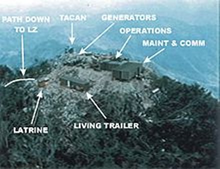
© 2016-Air Force Photo Mapping Association, and 1370th.org